Highpoints of Canada
Ishpatina Ridge
Ontario
Elevation 2,275 ft
Prominence 1,030 ft
Topo map 41 P/7 Smoothwater Lake
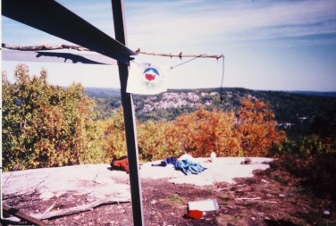
Deep in Lady Evelyn-Smoothwater Provincial Park, a series of exposed granite humps rise above the crystalline waters of the Canadian Shield. One of these humps, Ishpatina Ridge (meaning “high hill” in native Ojibwa language) was determined to be the highest point in Ontario in 1972.
The land surrounding Ishpatina Ridge is similar to that of Eagle Mountain, Minnesota. But reaching the summit is unique, since it requires a canoe trip through beautiful pristine lakes of the Canadian Shield. The rhythm of silently paddling through these scenic waters and lovely forests is a highpoint trip not to be forgotten.
The trip to Ishpatina Ridge begins at the Beauty Lake Road bridge over the Montreal River, about 30 miles east of Elk Lake, Ontario. From the bridge, paddle upstream on the Montreal River, and through Lady Dufferin and Smoothwater Lakes, a distance of about 10 miles. From the southern end of Smoothwater Lake, the route leads through series of 6 small lakes connected by well-maintained portages. Next descend tiny Scarecrow Creek to Scarecrow Lake. On the west bank of Scarecrow Lake is an old dock and abandoned warden cabin. From the cabin an overgrown trail leads 3 miles past isolated lakes to the open summit of Ishpatina Ridge. An antiquated fire tower marks the highest point in Ontario. Return to you car on the Beauty Lake Road by retracing the same route in reverse. 3-4 days is needed for the entire 41-mile journey.
Elevation 2,275 ft
Prominence 1,030 ft
Topo map 41 P/7 Smoothwater Lake
Deep in Lady Evelyn-Smoothwater Provincial Park, a series of exposed granite humps rise above the crystalline waters of the Canadian Shield. One of these humps, Ishpatina Ridge (meaning “high hill” in native Ojibwa language) was determined to be the highest point in Ontario in 1972.
The land surrounding Ishpatina Ridge is similar to that of Eagle Mountain, Minnesota. But reaching the summit is unique, since it requires a canoe trip through beautiful pristine lakes of the Canadian Shield. The rhythm of silently paddling through these scenic waters and lovely forests is a highpoint trip not to be forgotten.
The trip to Ishpatina Ridge begins at the Beauty Lake Road bridge over the Montreal River, about 30 miles east of Elk Lake, Ontario. From the bridge, paddle upstream on the Montreal River, and through Lady Dufferin and Smoothwater Lakes, a distance of about 10 miles. From the southern end of Smoothwater Lake, the route leads through series of 6 small lakes connected by well-maintained portages. Next descend tiny Scarecrow Creek to Scarecrow Lake. On the west bank of Scarecrow Lake is an old dock and abandoned warden cabin. From the cabin an overgrown trail leads 3 miles past isolated lakes to the open summit of Ishpatina Ridge. An antiquated fire tower marks the highest point in Ontario. Return to you car on the Beauty Lake Road by retracing the same route in reverse. 3-4 days is needed for the entire 41-mile journey.
