Highpoints of Canada
Mount Columbia
Alberta
Elevation 12,294 ft
Prominence 7,818 ft
Topo map 83 C/3 Columbia Icefield
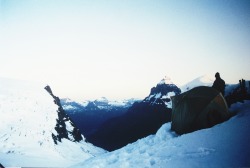
Mount Columbia, the highest point in Alberta, juts out of the northern edge of the Columbia Icefield, the largest icefield in the Rocky Mountains. Here in Jasper National Park, the icefield and surrounding peaks cause moisture-laden winds from the Pacific Ocean to rise abruptly, resulting in a dramatic 30 ft of snowfall per year. Snow and ice have accumulated to depths greater than 1000 ft, and 6 major glaciers flow outward from the icefield. Good weather on Mount Columbia seldom lasts long.
Mount Columbia is a snow and ice climb best compared to an assent of Mt. Rainier. The climber must contend with large, heavily crevassed glaciers, and possible avalanche conditions.
More than 90% of climbers ascend Mount Columbia by its east face. The usual approach to the mountain is via the Athabasca Glacier from Alberta Highway 93, known as the Icefields Parkway, about 60 miles south of Jasper. The area near the toe of the Athabasca Glacier is a popular tourist stop, and during the summer the scene is a bustle of activity. It is necessary to register all climbs and overnight hikes at the warden’s office. Park at the climber’s parking lot and walk the road used by Brewster Transport to access the upper portion of the glacier. Rope up and climb the right side of the glacier past two major icefalls to the Columbia Icefield. Both sides of the Athabasca Glacier are threatened by rockfall, and should be passed as quickly as possible. Once on the icefield, head directly for a large trench 4.5 miles east of Mount Columbia, and make camp in the trench. This is a long first day, climbing 8 miles to gain 2,900 ft in elevation and then losing 700 ft to the bottom of the trench. From a camp in the trench, head west toward Mount Columbia to the base of the summit pyramid. The east face of Mount Columbia, about 2,000 ft high and at an angle of about 45o, is usually climbed on the left (south) side. Mount Columbia has a double summit, so once the top of the east face is reached, scramble northwest down a few feet then up to the true summit, which is slightly higher.
To return to trench camp and the Athabasca Glacier, follow the same route in reverse. Highpointers may want to make a slight diversion on the return journey to make an easy climb to the summit of Snowdome. The summit of Snowdome is the triple divide peak for North America. From this one point, water drains into 3 oceans: the Atlantic, the Pacific and the Arctic. How cool it that!
Elevation 12,294 ft
Prominence 7,818 ft
Topo map 83 C/3 Columbia Icefield
Mount Columbia, the highest point in Alberta, juts out of the northern edge of the Columbia Icefield, the largest icefield in the Rocky Mountains. Here in Jasper National Park, the icefield and surrounding peaks cause moisture-laden winds from the Pacific Ocean to rise abruptly, resulting in a dramatic 30 ft of snowfall per year. Snow and ice have accumulated to depths greater than 1000 ft, and 6 major glaciers flow outward from the icefield. Good weather on Mount Columbia seldom lasts long.
Mount Columbia is a snow and ice climb best compared to an assent of Mt. Rainier. The climber must contend with large, heavily crevassed glaciers, and possible avalanche conditions.
More than 90% of climbers ascend Mount Columbia by its east face. The usual approach to the mountain is via the Athabasca Glacier from Alberta Highway 93, known as the Icefields Parkway, about 60 miles south of Jasper. The area near the toe of the Athabasca Glacier is a popular tourist stop, and during the summer the scene is a bustle of activity. It is necessary to register all climbs and overnight hikes at the warden’s office. Park at the climber’s parking lot and walk the road used by Brewster Transport to access the upper portion of the glacier. Rope up and climb the right side of the glacier past two major icefalls to the Columbia Icefield. Both sides of the Athabasca Glacier are threatened by rockfall, and should be passed as quickly as possible. Once on the icefield, head directly for a large trench 4.5 miles east of Mount Columbia, and make camp in the trench. This is a long first day, climbing 8 miles to gain 2,900 ft in elevation and then losing 700 ft to the bottom of the trench. From a camp in the trench, head west toward Mount Columbia to the base of the summit pyramid. The east face of Mount Columbia, about 2,000 ft high and at an angle of about 45o, is usually climbed on the left (south) side. Mount Columbia has a double summit, so once the top of the east face is reached, scramble northwest down a few feet then up to the true summit, which is slightly higher.
To return to trench camp and the Athabasca Glacier, follow the same route in reverse. Highpointers may want to make a slight diversion on the return journey to make an easy climb to the summit of Snowdome. The summit of Snowdome is the triple divide peak for North America. From this one point, water drains into 3 oceans: the Atlantic, the Pacific and the Arctic. How cool it that!
