Highpoints of Canada
Mount Nirvana
Northwest Territories
Elevation 9,097 ft
Prominence 5,456 ft
Topo maps 95 E/13 Mount Sidney Dobson and 95 E/14 Hole in the Wall Lake
A wild and little-known range of peaks named the MacKenzie Mountains lies near the Yukon boarder in the southwest corner of the Northwest Territories. Concealed deep within the MacKenzie Mountains is a cluster of dramatic spires known as the Ragged Range. And crowning the Ragged Range is a mysterious mountain that is unnamed on the topo map, and whose significance is obscured by its sharp summit, which does not allow plotting of all contour lines. This is Mount Nirvana, the highest mountain in the Northwest Territories. Mount Nirvana was first climbed in 1965, and has been climbed only 3 times since. This imposing granite spire has no non-technical route to the summit, daunting access problems, and unsettled weather any time of year. Mount Nirvana, more than any other, is the key to completing the Canadian Highpoints. It is a rock climb that is more technical than either Granite Peak or Gannett Peak, and its access is much more difficult than these.
There are two routes to the summit of Mount Nirvana, the North Face (the route of first assent) and the East Face (first climbed by the Bennett party in 1996). Both routes are difficult. The North Face is a mixed rock and ice climb, and is probably the harder of the two, so the route described here is the East Face, a rock climb rated about 5.7 YDS. The east face is best approached from Hole in the Wall Valley. But this valley lies within Nahanni National Park, and since Parks Canada stubbornly refuses any air landings on Hole in the Wall Lake or Lonely Lake, this is probably not an option. Unless a helicopter landing is used (seems a little like cheating), climbers must therefore land on Rabbitkettle Lake in Nahanni National Park. Various air charter services based in Ft. Liard, Ft. Nelson and Ft. Simpson can be used, including Deh Cho Air, Liard Tours, Simpson Air, and Wolverine Air.
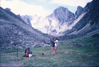
From Rabbitkettle Lake, cross the Rabbitkettle River on a hand-operated ferry and bushwhack through bogs, brush, and mosquitoes up the west bank of the River. This is very tough going! Cross Nightwind Creek five miles up the river and continue another 7.5 miles upriver on faint game trails. Turn west and follow a stream through dense brush and boulders to gain the meadows east of Mount Nirvana. The difficulty of this bushwhack cannot be overestimated.
From the meadows, approach the east face by first climbing to the toe of the glacier. Rope up and climb the glacier, cross the bergschrund at the bottom of the face, and ascend a 50o snowfield to a 400-ft rock band. This band is the crux of the route. The rock here is sound, but may be wet and slippery. From the top of the band, traverse right on a snowy ledge about 160 ft, then angle up and slightly left on narrow ledges to a detached flake on the south ridge. Once on the ridge, climb easily to the summit and delight in your achievement. Forget, for the moment, that you still have to retrace your route back to Rabbitkettle Lake through nearly impenetrable brush and incessant mosquitoes.
Elevation 9,097 ft
Prominence 5,456 ft
Topo maps 95 E/13 Mount Sidney Dobson and 95 E/14 Hole in the Wall Lake
A wild and little-known range of peaks named the MacKenzie Mountains lies near the Yukon boarder in the southwest corner of the Northwest Territories. Concealed deep within the MacKenzie Mountains is a cluster of dramatic spires known as the Ragged Range. And crowning the Ragged Range is a mysterious mountain that is unnamed on the topo map, and whose significance is obscured by its sharp summit, which does not allow plotting of all contour lines. This is Mount Nirvana, the highest mountain in the Northwest Territories. Mount Nirvana was first climbed in 1965, and has been climbed only 3 times since. This imposing granite spire has no non-technical route to the summit, daunting access problems, and unsettled weather any time of year. Mount Nirvana, more than any other, is the key to completing the Canadian Highpoints. It is a rock climb that is more technical than either Granite Peak or Gannett Peak, and its access is much more difficult than these.
There are two routes to the summit of Mount Nirvana, the North Face (the route of first assent) and the East Face (first climbed by the Bennett party in 1996). Both routes are difficult. The North Face is a mixed rock and ice climb, and is probably the harder of the two, so the route described here is the East Face, a rock climb rated about 5.7 YDS. The east face is best approached from Hole in the Wall Valley. But this valley lies within Nahanni National Park, and since Parks Canada stubbornly refuses any air landings on Hole in the Wall Lake or Lonely Lake, this is probably not an option. Unless a helicopter landing is used (seems a little like cheating), climbers must therefore land on Rabbitkettle Lake in Nahanni National Park. Various air charter services based in Ft. Liard, Ft. Nelson and Ft. Simpson can be used, including Deh Cho Air, Liard Tours, Simpson Air, and Wolverine Air.
From Rabbitkettle Lake, cross the Rabbitkettle River on a hand-operated ferry and bushwhack through bogs, brush, and mosquitoes up the west bank of the River. This is very tough going! Cross Nightwind Creek five miles up the river and continue another 7.5 miles upriver on faint game trails. Turn west and follow a stream through dense brush and boulders to gain the meadows east of Mount Nirvana. The difficulty of this bushwhack cannot be overestimated.
From the meadows, approach the east face by first climbing to the toe of the glacier. Rope up and climb the glacier, cross the bergschrund at the bottom of the face, and ascend a 50o snowfield to a 400-ft rock band. This band is the crux of the route. The rock here is sound, but may be wet and slippery. From the top of the band, traverse right on a snowy ledge about 160 ft, then angle up and slightly left on narrow ledges to a detached flake on the south ridge. Once on the ridge, climb easily to the summit and delight in your achievement. Forget, for the moment, that you still have to retrace your route back to Rabbitkettle Lake through nearly impenetrable brush and incessant mosquitoes.
Nirvana Expedition 1996
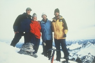
Tom, Hope, Jack and Dan Bennett
Jack and Tom summit Nirvana on their second attempt after being turned back in 1993. On this day Hope not only became the first female to reach Nirvana's summit but also turned 23. What a great way to spend a birthday!!
