Highpoints of Canada
Unnamed Point in the Cypress Hills - Saskatchewan 1392 m (4567 ft.)
Saskatchewan
Elevation 4,567 ft
Topo map 72 F/12 Hungerford Lakes
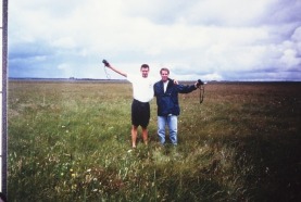
The Cypress Hills, rising nearly 2,000 ft above the surrounding prairie, are the highest elevation between the Canadian Rockies and the Torngat Mountains of Quebec. The Highpoint of Saskatchewan is similar to Black Mesa, Oklahoma, but without the long approach hike.
To reach the Highpoint, travel southwest from Maple Creek for 28 miles on Highway 271, then another 12 miles on dirt roads to the top of the Cypress Hills. The final dirt road that climbs past a ranch on the eastern side of the hills is suitable for passenger cars in dry weather, but a 4-wheel drive vehicle is needed if the road is wet. Drive through open range on top of the hills for another 2.5 miles. The exact location of the Highpoint is uncertain, but the elevation is marked on the topo map 350 ft off the left side of the road. This is the flattest Highpoint I have ever seen, bar none. A distance of one mile must be traveled to the south before the first contour line is reached!
Revel in the view (not!) and return to Maple Creek to wash the mud off your car.
Elevation 4,567 ft
Topo map 72 F/12 Hungerford Lakes
The Cypress Hills, rising nearly 2,000 ft above the surrounding prairie, are the highest elevation between the Canadian Rockies and the Torngat Mountains of Quebec. The Highpoint of Saskatchewan is similar to Black Mesa, Oklahoma, but without the long approach hike.
To reach the Highpoint, travel southwest from Maple Creek for 28 miles on Highway 271, then another 12 miles on dirt roads to the top of the Cypress Hills. The final dirt road that climbs past a ranch on the eastern side of the hills is suitable for passenger cars in dry weather, but a 4-wheel drive vehicle is needed if the road is wet. Drive through open range on top of the hills for another 2.5 miles. The exact location of the Highpoint is uncertain, but the elevation is marked on the topo map 350 ft off the left side of the road. This is the flattest Highpoint I have ever seen, bar none. A distance of one mile must be traveled to the south before the first contour line is reached!
Revel in the view (not!) and return to Maple Creek to wash the mud off your car.
