Highpoints of Canada
Mount Logan
Yukon Territory
Elevation 19,545 ft
Prominence 17,224 ft (6th highest in the world)
Topo maps 115 C/9 McArthur Peak and 115 C/10 King Peak
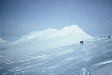
Mt. Logan, the second highest mountain in North America, is quite possibly the largest mountain on earth. It’s huge massif looms like a gigantic landlocked iceberg barely 50 miles from the Pacific Ocean. A full 40 square miles of Mt. Logan’s colossal summit plateau rises above 16,500 feet. It has the largest base circumference of any peak on earth. Mt. Logan rises from the largest icefield outside polar regions, a 45,000 square mile wilderness of snow and ice astride the boarder between Alaska and the Yukon Territory. The first assent of Mt. Logan in 1925 is perhaps the most extraordinary epic of hardship and endurance in the annals of North American mountaineering, and is well worth reading. The usual route to the summit, the King Trench route, follows in the path of that first assent.
The King Trench route is comparable to the West Buttress route on Denali. Some may argue that it is more challenging, since the hardest single pitch is a little harder than anything on the West Buttress, and because more time is usually required at high altitude. But the biggest difference between the King Trench and the West Buttress route is its isolation. Contact with other climbers high on the mountain is unlikely, and climbers should not depend on rescue in the event of trouble.
Kluane National Park officials carefully regulate Mt. Logan. Climbers must apply for a climbing permit at least 90 days prior to departure. Each climber must submit his climbing resume and results of a physical exam showing fitness for the climb. Park officials will scrutinize equipment and supplies, as well as plans showing schedule and campsites. Expeditions must have a minimum of 4 climbers, and splitting up is not permitted. Each climber will be charged $50 for a wilderness permit.
Plan 21 days for an assent of Mt. Logan. The climb begins with a ski-landing on the Quintino-Sella Glacier at about 9,000 ft. Fly-in services include Kluane Glacier Tours in Haines Junction, Ultima Thule Outfitters in Chitina River (recommended), and Alsek Air Service in Yakutat. The route climbs gradually to the third camp, King Col at 13,500 ft. Above King Col is the “headwall” a 1,500-ft 45o slope comparable to the headwall on the West Buttress route on Denali. The headwall is often prone to avalanche. Above the headwall a heavily crevassed glacier leads upward to Football Field Camp at 16,000 ft, and Windy Camp at 17,000 ft.
Above Windy Camp the route leads up through a pass and down onto the great summit plateau of Mt. Logan. The move through the pass is a decisive one, since escape from the plateau will require a climb back up through the pass to descend. The weather on the summit plateau has an especially evil reputation. Once on the summit plateau, the west peak of Mt. Logan looms above. Some tired climbers opt for the west peak, but it is about 100 ft lower than the true summit, and only the highest summit will do for a real Highpointer. Summit day involves traversing the north slope of the west peak, and climbing an icy 40o slope to a small notch north of the true summit. A final icy step (the hardest pitch of the climb) leads to the small summit. From here the happy climber can view endless isolated mountains of the icefield ranges, the Pacific Ocean, and south all the way to Mt. Fairweather in British Columbia. Retrace the route to the Quintino-Sella Glacier for the descent.
Elevation 19,545 ft
Prominence 17,224 ft (6th highest in the world)
Topo maps 115 C/9 McArthur Peak and 115 C/10 King Peak
Mt. Logan, the second highest mountain in North America, is quite possibly the largest mountain on earth. It’s huge massif looms like a gigantic landlocked iceberg barely 50 miles from the Pacific Ocean. A full 40 square miles of Mt. Logan’s colossal summit plateau rises above 16,500 feet. It has the largest base circumference of any peak on earth. Mt. Logan rises from the largest icefield outside polar regions, a 45,000 square mile wilderness of snow and ice astride the boarder between Alaska and the Yukon Territory. The first assent of Mt. Logan in 1925 is perhaps the most extraordinary epic of hardship and endurance in the annals of North American mountaineering, and is well worth reading. The usual route to the summit, the King Trench route, follows in the path of that first assent.
The King Trench route is comparable to the West Buttress route on Denali. Some may argue that it is more challenging, since the hardest single pitch is a little harder than anything on the West Buttress, and because more time is usually required at high altitude. But the biggest difference between the King Trench and the West Buttress route is its isolation. Contact with other climbers high on the mountain is unlikely, and climbers should not depend on rescue in the event of trouble.
Kluane National Park officials carefully regulate Mt. Logan. Climbers must apply for a climbing permit at least 90 days prior to departure. Each climber must submit his climbing resume and results of a physical exam showing fitness for the climb. Park officials will scrutinize equipment and supplies, as well as plans showing schedule and campsites. Expeditions must have a minimum of 4 climbers, and splitting up is not permitted. Each climber will be charged $50 for a wilderness permit.
Plan 21 days for an assent of Mt. Logan. The climb begins with a ski-landing on the Quintino-Sella Glacier at about 9,000 ft. Fly-in services include Kluane Glacier Tours in Haines Junction, Ultima Thule Outfitters in Chitina River (recommended), and Alsek Air Service in Yakutat. The route climbs gradually to the third camp, King Col at 13,500 ft. Above King Col is the “headwall” a 1,500-ft 45o slope comparable to the headwall on the West Buttress route on Denali. The headwall is often prone to avalanche. Above the headwall a heavily crevassed glacier leads upward to Football Field Camp at 16,000 ft, and Windy Camp at 17,000 ft.
Above Windy Camp the route leads up through a pass and down onto the great summit plateau of Mt. Logan. The move through the pass is a decisive one, since escape from the plateau will require a climb back up through the pass to descend. The weather on the summit plateau has an especially evil reputation. Once on the summit plateau, the west peak of Mt. Logan looms above. Some tired climbers opt for the west peak, but it is about 100 ft lower than the true summit, and only the highest summit will do for a real Highpointer. Summit day involves traversing the north slope of the west peak, and climbing an icy 40o slope to a small notch north of the true summit. A final icy step (the hardest pitch of the climb) leads to the small summit. From here the happy climber can view endless isolated mountains of the icefield ranges, the Pacific Ocean, and south all the way to Mt. Fairweather in British Columbia. Retrace the route to the Quintino-Sella Glacier for the descent.
